


Randonnée col de trebatut - la canourgue

jib971
User
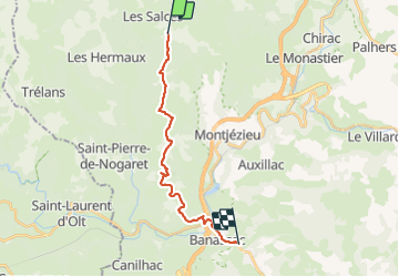

Length
17.7 km

Max alt
1101 m

Uphill gradient
250 m
Km-Effort
23 km

Min alt
523 m

Downhill gradient
767 m
Boucle
No
Creation date :
2021-09-04 07:06:40.0
Updated on :
2021-09-04 14:45:15.723
7h37
Difficulty : Easy

FREE GPS app for hiking
 SityTrail
IGN / Geographical institutes
SityTrail Plus
The world is yours!
About
Trail Walking of 17.7 km to be discovered at Occitania, Lozère, Les Salces. This trail is proposed by jib971.
Positioning
Country:
France
Region :
Occitania
Department/Province :
Lozère
Municipality :
Les Salces
Location:
Unknown
Start:(Dec)
Start:(UTM)
513559 ; 4930338 (31T) N.
Comments